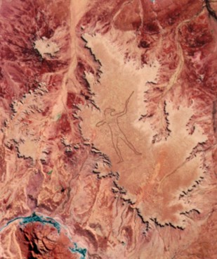
A 4 km human figure etched into the desert in 1998, visible only from the air. No one has claimed responsibility. Australia's largest and most mysterious modern geoglyph.
Lauren Dauphin, Public domain, via Wikimedia Commons
An unexpected discovery
On June 26, 1998, charter pilot Trec Smith was flying between the remote South Australian towns of Marree and Coober Pedy when he saw something impossible on the desert plateau below. Etched into the earth was a colossal figure of an Aboriginal hunter holding a woomera, or throwing stick. The discovery of the "Marree Man," also called "Stuart's Giant" in early anonymous faxes, immediately became a mystery. No one claimed responsibility, and no witnesses to its creation have ever come forward.
The geoglyph is immense. The figure is 4.2 kilometers (2.6 miles) tall with a total outline perimeter of 28 kilometers (17 miles). The lines themselves were originally dug 20 to 30 centimeters (8-12 inches) deep and measured up to 35 meters (115 feet) wide. Analysis of NASA Landsat 5 satellite imagery determined the work was created in a narrow window between May 27 and June 12, 1998. Experts estimate that creating the figure, presumably with a bulldozer or grader guided by GPS, would have taken weeks. Yet a police investigation found only a single track leading into and out of the site, with no other discernible footprints or tire marks.
Conflicting clues and theories
Shortly after the discovery, anonymous faxes were sent to local businesses and media. These press releases contained oddities that suggested a non-Australian creator, such as using imperial measurements and American-style phrases like "Queensland Barrier Reef." This led to speculation about involvement from American military personnel stationed at the nearby Woomera Prohibited Area.
This theory gained traction when a series of items were found in a small pit at the site. These included a jar containing a small U.S. flag, a satellite photo of the figure, and a note referencing the Branch Davidian group from Waco, Texas. In January 1999, another anonymous fax led officials to a buried plaque 5 meters south of the figure’s nose. It featured an American flag, the Olympic rings, and a quote from Hedley H. Finlayson's 1946 book "The Red Centre," describing Aboriginal hunters.
Another theory points to Bardius Goldberg, an artist from Alice Springs who died in 2002. Goldberg had previously expressed interest in creating a work of art visible from space and reportedly received a $10,000 payment around the time of the geoglyph's creation. He never publicly confirmed or denied his involvement. By the early 2010s, the figure had almost completely faded due to natural erosion. A group of local business owners, with the consent of the Arabana Aboriginal Corporation, undertook a restoration project in August 2016. Using GPS coordinates and a grader, they re-etched the outline over five days. They also created wind grooves intended to trap water, with the hope that vegetation will eventually grow, turning the lines green.
💡Fun Facts
The outline of the Marree Man is a near-perfect reverse image of the 5th-century BC Greek statue, the Artemision Bronze, which depicts either Zeus or Poseidon.
The creator likely used early GPS technology, which was not widely available to the public in 1998, to plot the figure's 28-kilometer perimeter with high precision.
During the 2016 restoration, workers discovered around 250 bamboo stakes that the original creator may have used to plot the outline, suggesting a surveyor's theodolite might have been used instead of GPS.
The site is on land belonging to the Arabana people, who were granted native title in 2012. The restoration project proceeded only after extensive consultation and their official consent.
Free to view, but requires chartering a scenic flight, with prices varying by operator.
Accessibility
The geoglyph is on private land and not accessible to the public on the ground. It can only be seen in its entirety from an aircraft at an altitude of over 3,000 feet.