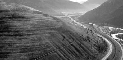
Glacial Lake Missoula burst its ice dam dozens of times, each flood releasing more water than all the world's rivers combined. The floodwaters carved the "Channeled Scablands" in days. What repeatedly triggered these ice dam failures remains unclear.
Public domain, via Wikimedia Commons
An ice dam 600 meters tall
Between 15,000 and 13,000 years ago, during the final stages of the Pleistocene Ice Age, a finger of the Cordilleran Ice Sheet crept south into what is now the Idaho Panhandle. This ice, a feature called the Purcell Trench Lobe, advanced across the Clark Fork River valley, forming a massive ice dam. This dam was immense, reaching a height of about 610 meters (2,000 feet) and stretching for miles.
Behind this towering wall of ice, the waters of the Clark Fork and its tributaries pooled, with no outlet to the Pacific Ocean. This created Glacial Lake Missoula, a prehistoric lake that inundated the mountain valleys of western Montana. At its maximum, the lake covered 7,770 square kilometers (3,000 square miles) and held an estimated 2,100 cubic kilometers (500 cubic miles) of water—a volume equal to Lake Erie and Lake Ontario combined., the water was up to 610 meters deep at the ice dam, and the city of Missoula would have been under hundreds of feet of water. Horizontal lines, called strandlines, are still visible on the mountainsides around Missoula, marking the ancient shorelines of the lake at its various levels.
A 130 km/h deluge
The immense pressure of the 2,100 cubic kilometers of water eventually caused the ice dam to fail. Geologists are still studying the precise failure mechanism; the water's depth may have provided enough hydrostatic pressure to float the massive ice dam, allowing water to begin tunneling underneath and rapidly destroying it.
The result was a cataclysmic glacial lake outburst flood. The entire volume of Lake Missoula could have drained in as little as 48 hours. At its peak, the discharge rate was an estimated 17 cubic kilometers per hour, a flow ten times greater than all the rivers of the world combined. Water moved at speeds approaching 130 km/h (80 mph).
This cycle of the ice dam forming, the lake filling, and the dam bursting repeated dozens of times over a 2,000-year period, with the lake taking an average of 55 years to refill. Each flood unleashed a torrent that scoured the landscape of eastern Washington, creating the channeled topography known today as the Channeled Scablands. These floods were powerful enough to carve canyons into solid basalt and transport house-sized boulders, known as glacial erratics, hundreds of miles. The floods also created giant current ripples—undulating ridges of gravel and boulders up to 15 meters (50 feet) high and hundreds of feet long that are visible today in places like Montana's Camas Prairie.
The theory of these catastrophic floods was first proposed in the 1920s by geologist J Harlen Bretz. His ideas were initially dismissed by the scientific community, which favored slow, uniform processes to explain geologic change. It took decades of accumulated evidence, including the discovery of the giant ripples and the identification of Glacial Lake Missoula as the source, for his hypothesis to be accepted.
💡Fun Facts
The largest Missoula flood released energy equivalent to 4,500 megatons of TNT.
Geologist J Harlen Bretz was ridiculed for his flood theory for 40 years before it was accepted. In 1979, at age 96, he received the Penrose Medal, geology's highest honor.
The torrents were so powerful they created "kolks"—titanic underwater whirlpools that drilled deep, circular potholes into the bedrock.
Boulders encased in icebergs from the dam were rafted as far as the Willamette Valley in Oregon, over 400 miles away.
The landscape features are always visible. For exhibits, the Montana Natural History Center in Missoula is open Monday-Saturday, 10am-4pm.
Admission
Access to the landscape is free. Admission applies at the Montana Natural History Center.
Accessibility
Viewing flood features like the Camas Prairie ripples or shoreline strandlines involves driving to roadside pullouts and viewpoints. Terrain is generally uneven. The Montana Natural History Center is accessible.